Regular Land
Land is almost like square or rectangle. Angles are perfect right angle.
Cross Angle Lands or Irregular Lots
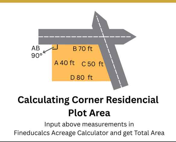
Any one side of land is tilted or oriented that is not straight to the other side of land. The all four sides of land may different. This time we need to measure corner to corner distance or angle of any one corner.
Calculating the area of land, a seemingly straightforward task, is a fundamental practice with far-reaching implications across various disciplines. From agriculture and real estate to urban planning and environmental conservation, understanding the precise extent of a parcel of land is crucial for informed decision-making.
Why Land Area Calculation Matters
Determining the precise extent of land is crucial across many fields:
- Agriculture: Essential for planning cultivation, irrigation, and resource management.
- Real Estate: A key factor in property value, taxation, and zoning regulations.
- Urban Planning: Informs infrastructure development and land use allocation.
- Environmental Conservation: Used to monitor and manage natural habitats.
Calculating Irregular Shaped Land Area
For rectangles and squares use first calculator. In real-world land boundaries can be complex. Here are some approaches for irregular shapes:
- If your land is with four sides and in irregular shape(irregular lot) use above second online tool. For Circles and other shape land are use appropriate formula to calculate area.
- Modern Surveying Technology: Tools like GPS and total stations provide boundary coordinates for area calculation using specialized software.
- Aerial and Satellite Imagery (GIS): For large and inaccessible areas, these technologies combined with Geographic Information Systems offer efficient area estimation and mapping.
First of all accurately calculating land area is very important. In agriculture, we need to know the amount of land available for cultivation, decisions about crop yield, irrigation, and fertilizer application depend on it. In real estate, the area is a primary factor in property valuation, taxation, and zoning regulations. Discrepancies may lead to legal disputes and financial losses. Urban planners must use precise area calculation tools for infrastructure development, land use allocation, and population density management. The accuracy of calculations may vary due to the size of area that measured.
Land Unit conversions
To calculate acreage and denoting in different areas it is different units were used. In various parts of the world in a acre of land, smaller denoting unit is varies to region to region.
In India, the measuring units were different to state to state. In telangana state 1 acre divided into 40 subparts as guntas, in Andhrapradesh subunit is called cent it is 100 th part in one acres. 1 Acre = 40 Gunthas, 1 Acre = 100 Cents.
In United States, for smaller land lots square feet unit and larger properties farms and estates acres were the units used widely.